Showing posts with label batangas. Show all posts
Tuesday, March 08, 2011
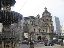
san juan nepomuceno church
the San Juan Nepomuceno church in San Juan, Batangas. i have attended many weddings and funerals masses in this church and according to our grandfathers, this church is already old... built during the Spanish colonial period. even as a kid, i have always love the structure of this old church... thanks to juday and ryan for putting this beautiful church on the map! :D
Monday, March 07, 2011
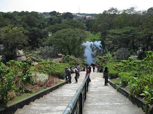
is the grass greener on the other side?
is the grass greener on the on the other side? hmmm come and walk with me and let's find out! :)
sure looks like the grass is indeed greener on the other side....
oh well... lookie what we have here - a rice field! that's why it's greener! :D
PS. pardon me for making fun at that famous saying...photos taken at San Juan, Batangas
Friday, February 05, 2010
Thursday, February 04, 2010
panutsa
Panutsa or panocha is a sweet treat that looks like a flat disk of crystallized dark brown sugar that is studded with peanuts. Typical "pasalubong" from southern tagalog provinces. so you like this one? as for me - i lurve it! :D
Wednesday, February 03, 2010
Tuesday, February 02, 2010
Thursday, January 15, 2009
mount makulot

i know, i know, this blog is all about manila, but i can't help myself share with you this beautiful scene. Photo: mount makulot in batangas
Fast facts:
Batangas is a province of the Philippines located on the southwestern part of Luzon in the CALABARZON region. Its capital is Batangas City and it is bordered by the provinces of Cavite and Laguna to the north and Quezon to the east. Across the Verde Island Passages to the south is the island of Mindoro and to the west lies the South China Sea.
Mount Makulot - is a mountain located in north-west of Cuenca, Batangas, Philippines. This mountain is a tourist attraction to the municipality. Sometimes, the mountain is called Mt. Maculot. The Mountain is about 600 m (2,000 ft) tall and it is also located next to Taal Lake. Mount Makulot, a 600-meter (2,000 feet) high volcanic rock wall, is said to be part of Taal Volcano’s crater rim. Some scientists contend that Taal Volcano was once a massive volcano before a violent eruption caused the slopes to cave in. This caused water to rush in, forming a lake that left only the tip of the previous peak exposed, and that is now known as the current Volcano Island. The slopes of the previous volcano now formed ridges surrounding the lake, with Mount Makulot as the highest volcanic cone on the south side.
Wednesday, October 17, 2007
taal volcano

This is the mouth of Taal Volcano (to know more about this beautiful volcano click here), yeah it's at Batangas, a province south of Manila but i wanted to share this with you, since it was in local news that the Philippines wanted to sell deadly volcanoes as tourist attraction. And with this photo, i guess you all had to agree that volcanoes, dangerous they may be are a beauty.
This photo was taken last year when me and my cousins decided to go inside the volcano (been inside the volcano twice!), from their place we rode a small banca (a 30 minute ride)then another 30min or so to hike up the volcano, and that photo is taken at the top, then another 30min to go down inside the volcano. The hike downhill is harder not because the slope is steep but the sand we're walking on are hot to the feet. They say that the lake in the volcano have healing stuff so we decided to try the water, it's luke warm but you can smell the sulfur... the 2nd time i went inside the volcano the alert level was up and you can see smoke coming up.
Tuesday, October 16, 2007
yipeee

A break from manila... went to Batangas last saturday to celebrate my cousins birthday, this is my nephew enjoying the serene life in the province. The mountain behind him is Mt. Makulot.

Subscribe to:
Posts (Atom)